Architecture study guide
Architecture site analysis: a worked example
Follow one illustrative plot from a recorded observation to a design decision. Use the same evidence register to explain the choices in your own site-study presentation.
1. Set a brief and identify what you know
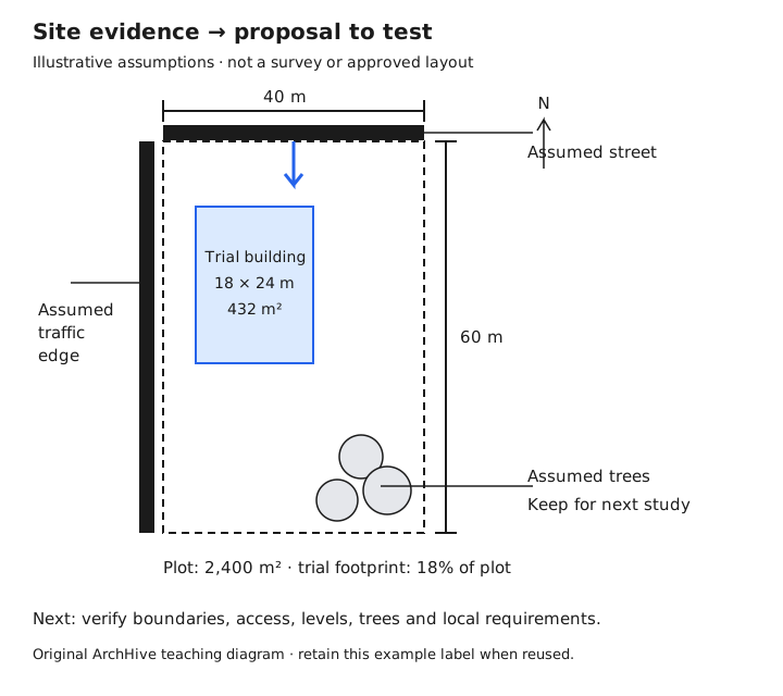
Assume a small learning centre on a rectangular plot measuring 40 m east–west by 60 m north–south. North is at the top of the diagram. The exercise assumes a street on the north edge, a busier street to the west and a group of existing trees in the south-east.
The plot area is 40 × 60 = 2,400 m². A trial building footprint of 18 × 24 = 432 m² would occupy 18% of the plot. This is an arithmetic comparison of one proposal, not an allowable coverage limit. No setbacks, floor-area entitlement or site levels have been established.
Write each input as measured, sourced or assumed. Here, every site input is assumed. A real project starts by replacing these assumptions with survey records and attributable sources.
2. Connect evidence to a response and a check
A useful site-analysis sheet explains what changes because of the evidence. Keep an explicit verification step so a plausible design idea is not presented as a measured result.
| Observation or assumption | Design response to test | Next verification |
|---|---|---|
| North edge: assumed public street | Test a direct entrance route to reception from the north. | Survey the boundary and check access permission, levels and pedestrian movement. |
| West edge: assumed traffic noise | Compare a service zone along the west edge with a centrally placed building. | Record noise at different times; assess the envelope before claiming an acoustic benefit. |
| South-east: assumed existing trees | Keep the tree area outside the trial footprint and test an outdoor learning space. | Survey tree positions, canopy and roots before fixing the layout. |
| Sun, wind and drainage: not measured | Keep shading, ventilation and level decisions open. | Test them with the real location, dates, climate sources and measured levels. |
3. Compare two options using the same inputs
Option A: a central footprint. Start with the same 18 × 24 m rectangle in the middle of the plot. It leaves open space around the building, but test whether arrival paths and outdoor activities compete for the same space.
Option B: a western service edge. Move the trial footprint toward the west and test service rooms on that side, a northern entrance and open space toward the trees. This responds to the assumed context; it does not prove that noise, comfort or access requirements have been resolved.
Keep the footprint area, diagram scale and brief constant in both studies. Record access distance, usable outdoor space and the relationships between rooms. Choose an option for the next investigation and state which missing evidence could change the decision. In this exercise, Option B is a candidate for further testing because it separates the proposed outdoor space from the western edge.
4. Build a sheet that explains the decision
- Locate the plot. Show the source, north direction, dimensions, scale and survey status. Credit the source of any map used.
- Separate observations from assumptions. Keep only the context that affects the brief, with dates and a source register.
- Draw the alternatives at the same scale. Show arrival, service relationships and outdoor space rather than decorating every edge with symbols.
- Explain one choice. Connect an observation to the proposed response, then name the check needed before the decision can be fixed.
The files contain this same illustrative example. Replace the assumptions with your own site evidence; retain the example label if you reuse the diagram.
Checks to complete on your real site
Climate and comfort
Record the location, dates and sources used for sun and wind studies. Compare seasonal conditions before selecting shading or ventilation strategies. A diagram generated for a different latitude is not evidence for your site.
Access and circulation
Map street connections, walking routes, deliveries, public transport and changes in level. Distinguish an observed route from an assumed entrance. Verify accessibility and emergency access against the requirements that actually apply to the project.
Planning and context
Find the responsible authority and the current documents for the parcel. Record the source, edition and verification status of each requirement. Do not treat an illustrative offset or coverage calculation as a permitted setback or development entitlement.
People and place
Document who uses the site, when they use it and what activities need support. Use attributed observations and permitted interviews. Keep an observation, your interpretation and your proposed design response as separate entries.